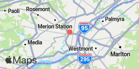
Latitude
39° 57' 18" N (39.955)
Longitude
75° 10' 48" W (-75.18)
State
County
Nearest ZIP
19103
Nearby
Tides
2.2 mi
Philadelphia, Municipal Pier 11
2.5 mi
Philadelphia (USCG Station), Delaware River
4.0 mi
Pavonia, Cooper River, RR. bridge
4.3 mi
Penrose Avenue Bridge, Schuylkill River
5.6 mi
Bridesburg, Philadelphia
6.4 mi
Westville, Rt. 47 bridge, Big Timber Creek
6.5 mi
Tinicum National Wildlife Refuge, Darby Creek
6.6 mi
Woodbury Creek
7.8 mi
Norwood City, Darby Creek
8.2 mi
Billingsport
8.3 mi
Tacony-Palmyra Bridge
8.5 mi
Palmyra, Pennsauken Creek, Route 73 bridge
8.6 mi
Wanamaker Bridge, Darby Creek
8.9 mi
Paulsboro, Mantua Creek
10.0 mi
Pompeston Creek
11.1 mi
Mantua, Mantua Creek
Currents
2.2 mi
Philadelphia, Penns Landing
3.0 mi
Kaighn Point
3.4 mi
Petty Island, Delaware River
4.4 mi
Girard Point
4.7 mi
Gloucester Point
5.2 mi
Eagle Point, 0.2 n.mi. northwest of
5.7 mi
Fisher Point
6.4 mi
Hog Island, channel southeast of
7.5 mi
Mantua Creek Anchorage
8.9 mi
Frankford Range at Tacony Range
9.0 mi
Mantua Creek US 44 Bridge Paulsboro
9.3 mi
Crab Point, 0.5 mi East of
10.9 mi
Eddystone
