Uncatena Island (South Side) Weekly Tide Tables and Charts
Tide Chart for Next 7 Days
Uncatena Island (South Side) weekly tide chart key:
The tide chart above shows the times and heights of high tide and low tide for Uncatena Island (South Side), for the next seven days. The red line highlights the current time and estimated height.The tidal range at Uncatena Island (South Side) for the next seven days is approximately 4.50 ft with a minimum tide of -0.18 ft and maximum tide of 4.32 ft. You can also check out all the daily details on tides & fishing times on the Day tab for Uncatena Island (South Side).
Tide Table for Next 7 Days
▲ Blue = High Tide
▼ Red = Low Tide
| Day | 1st Tide | 2nd Tide | 3rd Tide | 4th Tide | ☀ Sun |
Major Solunars
|
Minor Solunars
|
|
|---|---|---|---|---|---|---|---|---|
| 4 Mon |
|
▲ 2.59 ft |
▼ 0.79 ft |
▲ 3.24 ft |
▼ 0.83 ft |
▲ 5:41 AM ▼ 7:56 PM |
8:45 AM → 10:45 AM 9:10 PM → 11:10 PM |
12:38 AM → 1:38 AM 4:52 PM → 5:52 PM |
| 5 Tue |
|
▲ 2.71 ft |
▼ 0.67 ft |
▲ 3.41 ft |
▲ 5:42 AM ▼ 7:55 PM |
9:35 AM → 11:35 AM 10:04 PM → 12:04 AM |
1:24 AM → 2:24 AM 5:47 PM → 6:47 PM |
|
| 6 Wed |
|
▼ 0.66 ft |
▲ 2.93 ft |
▼ 0.5 ft |
▲ 3.64 ft |
▲ 5:43 AM ▼ 7:54 PM |
10:28 AM → 12:28 PM 10:59 PM → 12:59 AM |
2:20 AM → 3:20 AM 6:36 PM → 7:36 PM |
| 7 Thu |
|
▼ 0.47 ft |
▲ 3.21 ft |
▼ 0.32 ft |
▲ 3.9 ft |
▲ 5:44 AM ▼ 7:53 PM |
11:20 AM → 1:20 PM 11:53 PM → 1:53 AM |
3:24 AM → 4:24 AM 7:17 PM → 8:17 PM |
| 8 Fri |
|
▼ 0.28 ft |
▲ 3.49 ft |
▼ 0.16 ft |
▲ 4.12 ft |
▲ 5:45 AM ▼ 7:51 PM |
12:12 PM → 2:12 PM |
4:35 AM → 5:35 AM 7:50 PM → 8:50 PM |
| 9 Sat |
|
▼ 0.09 ft |
▲ 3.76 ft |
▼ 0.04 ft |
▲ 4.27 ft |
▲ 5:46 AM ▼ 7:50 PM |
12:45 AM → 2:45 AM 1:03 PM → 3:03 PM |
5:48 AM → 6:48 AM 8:18 PM → 9:18 PM |
| 10 Sun |
|
▼ -0.06 ft |
▲ 3.99 ft |
▼ -0.03 ft |
▲ 4.32 ft |
▲ 5:47 AM ▼ 7:49 PM |
1:35 AM → 3:35 AM 1:52 PM → 3:52 PM |
7:01 AM → 8:01 AM 8:43 PM → 9:43 PM |
Buoy Weather
Air Temperature
67.5° F
Water Temperature
72.3° F
Atmospheric Pressure
30.11 in
Note: Observations are from a weather buoy 1.95 miles from the prediction site. Observations are not available at all prediction sites, and observation types vary between sites.
More details: Station bzbm3 Buoy Weather
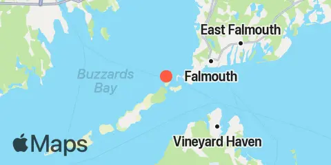
Location & Map
Latitude
41° 31' 12" N (41.52)
Longitude
70° 42' 30" W (-70.7083)
State
County
Nearest ZIP
02543
Nearby
Tides
1.9 mi
Woods Hole, Buzzards Bay
2.2 mi
Little Harbor, Woods Hole
5.9 mi
Cedar Tree Neck, Martha's Vineyard
6.2 mi
Falmouth Heights, Nantucket Sound
6.6 mi
Chapoquoit Point, West Falmouth Harbor, Buzzards Bay
7.0 mi
Vineyard Haven Harbor, Vineyard Haven
9.0 mi
Oak Bluffs, Martha's Vineyard
9.1 mi
Quicks Hole, North side
10.9 mi
Mattapoisett, Mattapoisett Harbor, Buzzards Bay
11.1 mi
Clarks Point, New Bedford, Buzzards Bay
11.5 mi
Round Hill Point, Buzzards Bay
11.9 mi
Menemsha Harbor
12.1 mi
Penikese Island, Buzzards Bay
12.1 mi
Piney Point, Buzzards Bay
Currents
0.8 mi
North end
1.3 mi
Woods Hole, The Strait
1.8 mi
Weepecket Island, south of
1.9 mi
Juniper Point
3.5 mi
Tarpaulin Cove, 1.5 miles east of
3.6 mi
Nobska Point, 1 mile southeast of
4.2 mi
Norton Point, 0.5 mile north of
4.7 mi
Nobska Point, 1.8 miles east of
5.7 mi
West Chop, 0.2 mile west of
6.2 mi
West Chop, 0.8 mile north of
6.2 mi
West Island, 1 mile Southeast of
6.8 mi
L'Hommedieu Shoal, north of west end
7.0 mi
Robinsons Hole, 1.2 miles southeast of
7.0 mi
Robinsons Hole, Nashuon Point
7.8 mi
Cleveland Ledge
8.1 mi
East Chop, 1 mile north of
8.7 mi
North end
8.9 mi
South end
8.9 mi
Hedge Fence-L'Hommedieu Shoal, between
9.0 mi
Middle
9.4 mi
Waquoit Bay entrance
9.7 mi
East Chop-Squash Meadow, between
10.1 mi
Gay Head, 3 miles northeast of
10.9 mi
Dumpling Rocks, 0.2 mile southeast of
11.1 mi
Gay Head, 3 miles north of
11.6 mi
Gull I. and Nashawena I., between
11.9 mi
Abiels ledge
12.1 mi
Hedge Fence Lighted Gong Buoy 22
12.3 mi
Canapitsit Channel
12.4 mi
Penikese Island, 0.2 mile south of
Note: Tide predictions are an estimate and NOT FOR NAVIGATION.
We also offer free widgets if you want to add tide or solunar tables to your own site.