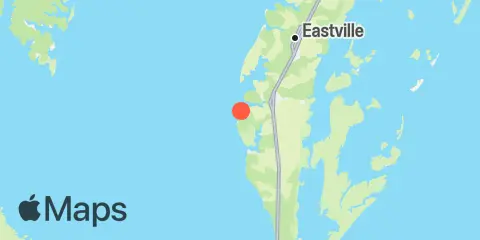
Latitude
37° 15' 48" N (37.2633)
Longitude
76° 1' 12" W (-76.02)
State
County
Nearest ZIP
23310
Nearby
Tides
2.7 mi
Old Plantation Light, Chesapeake Bay
5.5 mi
Oyster Harbor
7.0 mi
Kiptopeke Beach, Chesapeake Bay
11.4 mi
Smith Island (Coast Guard Station)
11.7 mi
Fishermans Island, Chesapeake Bay
Currents
3.4 mi
Old Plantation Flats Lt., 0.5 mi. W of
4.1 mi
Cape Charles City, 3.3 n.mi. west of
7.4 mi
Butler Bluff, 2.1 n.mi. WSW of
7.5 mi
York Spit Channel, N of Buoy '26'
8.9 mi
Wolf Trap Light, 5.8 miles east of
9.6 mi
New Point Comfort, 4.1 n.mi. ESE of
9.7 mi
Church Neck Point, 1.9 n.mi. W of
10.3 mi
Wolf Trap Light, 6.1 n.mi. ENE of
10.6 mi
York River Entrance Channel (SE end)
10.6 mi
Wolf Trap Light, 5.2 n.mi. ENE of
10.6 mi
Cape Charles, off Wise Point
10.8 mi
Fishermans I., 1.1 miles northwest of
11.2 mi
Fishermans I., 1.4 n.mi. WNW of
11.9 mi
Fishermans I., 0.4 mile west of
