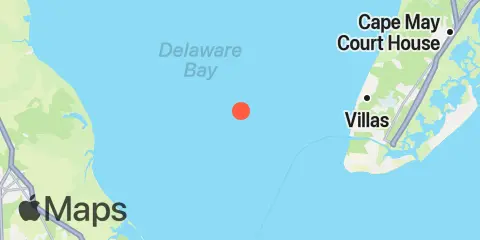
Latitude
38° 59' 12" N (38.9867)
Longitude
75° 6' 48" W (-75.1133)
State
County
Nearby
Tides
8.1 mi
Cape May Point, Sunset Beach, Delaware Bay
8.3 mi
Cape May Canal, Cape May, Delaware Bay
8.9 mi
North Highlands Beach, Delaware Bay
10.4 mi
Cape May (Ocean)
11.1 mi
Cape Island Creek, Cape May
11.1 mi
Mispillion River entrance, Delaware Bay
12.2 mi
Cape May Harbor, Cape May Inlet
Currents
0.7 mi
Brandywine Shoal Light, 0.5 nm west of
3.3 mi
Delaware Bay Channel LB 10
3.9 mi
Big Stone Beach Anchorage, buoy "G"
4.3 mi
Fourteen Ft. Bank Lt., 1.4 n.mi. SSE of
5.3 mi
Fourteen Ft. Bank Lt., 1.2 mi. east of
6.0 mi
Deadman Shoal, 3.1 n.mi. SW of
7.3 mi
Cape Henlopen, 5 mi north of
7.7 mi
Cape May Canal, West End
8.1 mi
Brandywine Range at Miah Maull Range
8.1 mi
Broadkill Slough
8.3 mi
Egg Island Flats
8.8 mi
Big Stone Beach, 2.8 miles southeast of
9.2 mi
Cape May Point, 1.4 n.mi. SSW of
9.3 mi
Big Stone Beach, 2.2 n.mi. ENE of
9.4 mi
Delaware Bay Entrance
9.5 mi
Bay Shore Channel (north)
9.6 mi
Cape May Point, 2.7 n.mi. SSW of
9.9 mi
Cape May Channel
10.0 mi
Cape Henlopen, 4.8 n.mi. northeast of
11.2 mi
Mispillion River mouth
11.7 mi
Cape May Canal, east end
12.0 mi
Cape Henlopen, 2 mi NE of
