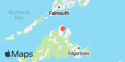
Latitude
41° 27' 30" N (41.4583)
Longitude
70° 36' 0" W (-70.6)
State
County
Nearest ZIP
02568
Nearby
Tides
2.3 mi
Oak Bluffs, Martha's Vineyard
5.3 mi
Cedar Tree Neck, Martha's Vineyard
5.4 mi
Little Harbor, Woods Hole
5.8 mi
Woods Hole, Buzzards Bay
6.0 mi
Falmouth Heights, Nantucket Sound
6.7 mi
Edgartown, Martha's Vineyard
7.0 mi
Uncatena Island (south side), Woods Hole
9.1 mi
Martha's Vineyard GPS buoy, Martha's Vineyard
10.2 mi
Wasque Point, Chappaquiddick Island, Martha's Vineyard
10.5 mi
Chapoquoit Point, West Falmouth Harbor, Buzzards Bay
11.3 mi
Menemsha Harbor
11.4 mi
Poponesset Island, Poponesset Bay, Nantucket Sound
Currents
1.8 mi
West Chop, 0.2 mile west of
2.4 mi
West Chop, 0.8 mile north of
2.8 mi
East Chop, 1 mile north of
3.3 mi
East Chop-Squash Meadow, between
3.4 mi
Norton Point, 0.5 mile north of
3.7 mi
Nobska Point, 1 mile southeast of
4.3 mi
Nobska Point, 1.8 miles east of
4.6 mi
Hedge Fence-L'Hommedieu Shoal, between
4.9 mi
L'Hommedieu Shoal, north of west end
5.4 mi
Juniper Point
6.0 mi
Woods Hole, The Strait
6.1 mi
Hedge Fence Lighted Gong Buoy 22
6.5 mi
Cape Poge Light, 1.4 miles west of
6.5 mi
Tarpaulin Cove, 1.5 miles east of
6.6 mi
North end
7.2 mi
Waquoit Bay entrance
7.9 mi
Weepecket Island, south of
9.5 mi
Robinsons Hole, 1.2 miles southeast of
9.8 mi
Cape Poge Lt., 1.7 miles SSE of
10.3 mi
Wreck Shoal-Eldridge Shoal, between
10.4 mi
Cape Poge Lt., 3.2 miles northeast of
10.7 mi
Robinsons Hole, Nashuon Point
10.8 mi
Gay Head, 3 miles northeast of
12.0 mi
Muskeget Channel
