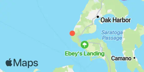
Latitude
48° 13' 54" N (48.2317)
Longitude
122° 45' 54" W (-122.765)
State
County
Nearest ZIP
98239
Nearby
Tides
3.5 mi
Coupeville, Penn Cove, Whidbey Island
4.0 mi
Sunset Beach, Whidbey Island, Strait of Juan de Fuca
6.7 mi
Smith Island, Strait of Juan de Fuca
6.8 mi
Admiralty Head, Admiralty Inlet
7.8 mi
Crescent Harbor, N. Whidbey Island
8.2 mi
Port Townsend (Point Hudson), Admiralty Inlet
8.5 mi
Naval Air Station Whidbey Island
10.3 mi
Marrowstone Point, Admiralty Inlet
Currents
4.5 mi
Smith Island, 3.4 mi. ESE of
4.7 mi
Point Partridge, 3.7 miles west of
5.2 mi
Point Wilson, 2.7 mi. NE of
5.5 mi
Point Wilson, 1.6 mi. NE of
5.7 mi
Point Wilson, 0.6 mi. NE of
5.8 mi
Point Wilson, 0.8 mile east of
6.1 mi
Smith Island, 1.4 miles SSW of
8.5 mi
Marrowstone Point, 1.1 miles northwest of
9.1 mi
Marrowstone Point, 1.65 mi. NE of
9.7 mi
Marrowstone Point, 0.8 mi. NE of
10.5 mi
Violet Point, 3.7 mi. NW of Protection Island
10.7 mi
West of Camano Island
11.1 mi
Skagit Bay, 1 mi. north of Rocky Point
11.2 mi
Smith Island, 5.5 mi. WNW of
11.9 mi
Colville Island, 1 mile SSE of
