Tides

Burrows Bay (Allan Island) tide chart key:

The tide chart above shows the times and heights of high tide and low tide for Burrows Bay (Allan Island), as well as solunar period times (represented by fish icons). The red line highlights the current time and estimated height.
2 Fish - Minor Solunar = Minor Solunar / Heightened Fish Activity
4 Fish - Major Solunar = Major Solunar / Very Heightened Fish Activity
Day Tide Time Height
21 Sat High 7:58 PM 5.15 ft
22 Sun Low 2:13 AM 1.67 ft
22 Sun High 10:10 AM 8.49 ft
22 Sun Low 5:20 PM 3.43 ft
22 Sun High 9:40 PM 4.64 ft
23 Mon Low 2:59 AM 2.86 ft

Sunday, December 22, 2024 6:14 PM: The tide is currently rising at Burrows Bay (Allan Island) with a current estimated height of 3.6 ft. The last tide was Low at 5:20 PM and the next tide is a High of 4.64 ft at 9:40 PM. The tidal range today is approximately 6.82 ft with a minimum tide of 1.67 ft and maximum tide of 8.49 ft.

Solunars & Sun/Moon Times

Last Quarter
Last Quarter 50%
Major Solunar
5:55 AM 7:55 AM
6:21 PM 8:21 PM
Minor Solunar
--:-- --:--
12:04 PM 1:04 PM
Moonrise
--:--
Moonset
12:04 PM
Sunrise
8:01 AM
Sunset
4:19 PM

Current Weather

Air Temperature
51.3° F
Wind
9.9 knots ESE (120°)
Atmospheric Pressure
29.77 in

Note: Observations are from a weather buoy 10.37 miles from the prediction site. Observations are not available at all prediction sites, and the number/type of observations varies between sites.

More details: Station pbfw1 Buoy Weather

Next 7 Days

▲ Blue = High Tide ▼ Red = Low Tide
Day 1st Tide 2nd Tide 3rd Tide 4th Tide Sun Major Solunars Very heightened fish activity Minor Solunars Heightened fish activity
22 Sun Last Quarter 50% 2:13 AM
1.67 ft
10:10 AM
8.49 ft
5:20 PM
3.43 ft
9:40 PM
4.64 ft
8:01 AM 4:19 PM 5:55 AM 7:55 AM
6:21 PM 8:21 PM
12:04 PM 1:04 PM
23 Mon Waning Crescent 49% 2:59 AM
2.86 ft
10:33 AM
8.33 ft
5:55 PM
2.53 ft
8:01 AM 4:20 PM 6:34 AM 8:34 AM
7:01 PM 9:01 PM
12:39 AM 1:39 AM
12:17 PM 1:17 PM
24 Tue Waning Crescent 40% 12:44 AM
4.84 ft
3:50 AM
4.05 ft
10:54 AM
8.22 ft
6:24 PM
1.66 ft
8:01 AM 4:20 PM 7:13 AM 9:13 AM
7:41 PM 9:41 PM
1:45 AM 2:45 AM
12:30 PM 1:30 PM
25 Wed Waning Crescent 31% 2:37 AM
5.82 ft
4:54 AM
5.14 ft
11:15 AM
8.13 ft
6:52 PM
0.84 ft
8:02 AM 4:21 PM 7:54 AM 9:54 AM
8:24 PM 10:24 PM
2:52 AM 3:52 AM
12:46 PM 1:46 PM
26 Thu Waning Crescent 23% 3:38 AM
6.84 ft
6:07 AM
6 ft
11:39 AM
8.06 ft
7:20 PM
0.11 ft
8:02 AM 4:22 PM 8:38 AM 10:38 AM
9:09 PM 11:09 PM
4:02 AM 5:02 AM
1:05 PM 2:05 PM
27 Fri Waning Crescent 15% 4:21 AM
7.69 ft
7:19 AM
6.59 ft
12:05 PM
8.02 ft
7:51 PM
-0.54 ft
8:02 AM 4:22 PM 9:25 AM 11:25 AM
9:57 PM 11:57 PM
5:13 AM 6:13 AM
1:30 PM 2:30 PM
28 Sat Waning Crescent 9% 4:57 AM
8.3 ft
8:21 AM
6.92 ft
12:33 PM
8.01 ft
8:24 PM
-1.08 ft
8:02 AM 4:23 PM 10:16 AM 12:16 PM
10:47 PM 12:47 AM
6:24 AM 7:24 AM
2:04 PM 3:04 PM

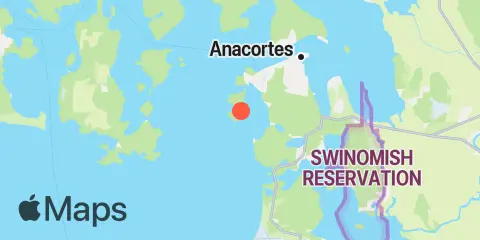
Location & Map

Latitude
48° 27' 36" N (48.46)
Longitude
122° 41' 42" W (-122.695)
State
County
Nearest ZIP
98221
Nearby
Tides 3.3 mi Ship Harbor, Fidalgo Island 3.7 mi Deception Pass St. Park, Bowman Bay, Fidalgo I. 4.9 mi Yokeko Point, Deception Pass 5.2 mi Telegraph Bay 5.2 mi Cornet Bay, Deception Pass 5.3 mi Anacortes, Guemes Channel 6.5 mi Turner Bay, Similk Bay 6.6 mi Ala Spit, Whidbey Island 7.0 mi Armitage Island, Thatcher Pass 7.4 mi Strawberry Bay, Cypress Island 7.6 mi Aleck Bay, Lopez Island 7.9 mi Sneeoosh Point 8.1 mi Naval Air Station Whidbey Island 8.3 mi Swinomish Channel entrance, Padilla Bay 9.1 mi Tide Point, Cypress Island 9.4 mi Richardson, Lopez Island, San Juan Channel 10.2 mi La Conner, Swinomish Channel 10.8 mi Peavine Pass 11.6 mi Upright Head, Lopez Island 11.9 mi Smith Island, Strait of Juan de Fuca 12.3 mi Sunset Beach, Whidbey Island, Strait of Juan de Fuca Currents 0.6 mi Burrows Bay, 0.5 mile east of Allan I 0.8 mi Allan Pass 2.1 mi Burrows Pass 2.5 mi Rosario Strait 3.0 mi Belle Rock Light, east of 3.1 mi Green Point, 0.8 mile northwest of 3.9 mi Point Colville, 3.0 nm east of (Lawson Reef, 1 nm 4.4 mi Deception Pass (Narrows) 4.7 mi Guemes Channel, West Entrance 4.9 mi Point Colville, 1.4 nm east of 5.0 mi Yokeko Point, Deception Pass 5.5 mi Fauntleroy Point Light, east of 5.5 mi Bellingham Channel South 5.8 mi Lopez Pass 6.2 mi Guemes Channel, East Entrance 6.8 mi Skagit Bay channel, SW of Hope Island 6.8 mi Thatcher Pass 7.0 mi Colville Island, 1 mile SSE of 7.0 mi Bellingham Channel, off Cypress Head Light 7.5 mi Strawberry Island, west of 8.0 mi Saddle Bag Island Passage 8.3 mi Frost-Willow Island, between 8.4 mi Huckleberry Island, 0.5 mile north of 9.3 mi Bellingham Channel North Entrance 10.5 mi Peavine Pass, west entrance 10.5 mi Towhead Island, 0.4 mile east of 10.5 mi Skagit Bay, 1 mi. south of Goat Island 11.3 mi Obstruction Pass, north of Obstruction Island 11.5 mi Iceberg Point, 2.1 miles SSW of 11.5 mi Peapod Rocks Light, 1.2 nm south of 11.7 mi Cattle Point, 1.2 nm SE of 11.8 mi San Juan Channel, south entrance 11.9 mi Smith Island, 3.4 mi. ESE of 12.1 mi Kings Point, Lopez Island, 1 mile NNW of 12.3 mi Upright Channel narrows 12.3 mi Pear Point, east of

Note: Tide predictions are an estimate and NOT FOR NAVIGATION.

We also offer free widgets if you want to add tide or solunar tables to your own site.