Chesapeake Bay Bridge-Tunnel Weekly Tide Tables and Charts
Tide Chart for Next 7 Days
Chesapeake Bay Bridge-Tunnel weekly tide chart key:
The tide chart above shows the times and heights of high tide and low tide for Chesapeake Bay Bridge-Tunnel, for the next seven days. The red line highlights the current time and estimated height.The tidal range at Chesapeake Bay Bridge-Tunnel for the next seven days is approximately 3.29 ft with a minimum tide of -0.05 ft and maximum tide of 3.24 ft. You can also check out all the daily details on tides & fishing times on the Day tab for Chesapeake Bay Bridge-Tunnel.
Tide Table for Next 7 Days
▲ Blue = High Tide
▼ Red = Low Tide
| Day | 1st Tide | 2nd Tide | 3rd Tide | 4th Tide | ☀ Sun |
Major Solunars
|
Minor Solunars
|
|
|---|---|---|---|---|---|---|---|---|
| 24 Thu |
|
▼ 0.04 ft |
▲ 2.55 ft |
▼ -0.05 ft |
▲ 3.21 ft |
▲ 6:04 AM ▼ 8:18 PM |
12:42 AM → 2:42 AM 1:09 PM → 3:09 PM |
5:31 AM → 6:31 AM 8:37 PM → 9:37 PM |
| 25 Fri |
|
▼ 0.01 ft |
▲ 2.65 ft |
▼ -0.03 ft |
▲ 3.13 ft |
▲ 6:04 AM ▼ 8:17 PM |
1:40 AM → 3:40 AM 2:02 PM → 4:02 PM |
6:43 AM → 7:43 AM 9:12 PM → 10:12 PM |
| 26 Sat |
|
▼ 0.02 ft |
▲ 2.72 ft |
▼ 0.05 ft |
▲ 3 ft |
▲ 6:05 AM ▼ 8:16 PM |
2:32 AM → 4:32 AM 2:51 PM → 4:51 PM |
7:52 AM → 8:52 AM 9:41 PM → 10:41 PM |
| 27 Sun |
|
▼ 0.07 ft |
▲ 2.75 ft |
▼ 0.17 ft |
▲ 2.84 ft |
▲ 6:06 AM ▼ 8:16 PM |
3:19 AM → 5:19 AM 3:36 PM → 5:36 PM |
8:57 AM → 9:57 AM 10:05 PM → 11:05 PM |
| 28 Mon |
|
▼ 0.16 ft |
▲ 2.76 ft |
▼ 0.32 ft |
▲ 2.65 ft |
▲ 6:07 AM ▼ 8:15 PM |
4:02 AM → 6:02 AM 4:18 PM → 6:18 PM |
9:59 AM → 10:59 AM 10:28 PM → 11:28 PM |
| 29 Tue |
|
▼ 0.26 ft |
▲ 2.74 ft |
▼ 0.47 ft |
▲ 6:08 AM ▼ 8:14 PM |
4:43 AM → 6:43 AM 4:59 PM → 6:59 PM |
10:59 AM → 11:59 AM 10:50 PM → 11:50 PM |
|
| 30 Wed |
|
▲ 2.46 ft |
▼ 0.37 ft |
▲ 2.72 ft |
▼ 0.59 ft |
▲ 6:08 AM ▼ 8:13 PM |
5:23 AM → 7:23 AM 5:39 PM → 7:39 PM |
11:57 AM → 12:57 PM 11:13 PM → 12:13 AM |
Buoy Weather
Air Temperature
79.0° F
Wind
9.9 knots ESE (120°)
Wind Gust
12.1 knots
Atmospheric Pressure
30.16 in
Note: Observations are from a weather buoy 4.82 miles from the prediction site. Observations are not available at all prediction sites, and observation types vary between sites.
More details: Station chbv2 Buoy Weather
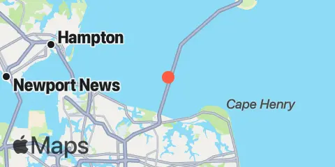
Location & Map
Nearby
Tides
4.3 mi
Virginia pilot's dock, Lynnhaven Inlet, Chesapeake Bay
4.9 mi
Chesapeake Bay Bridge-Tunnel, Chesapeake Bay
5.0 mi
Long Creek, Lynnhaven Bay
5.1 mi
Bayville, Lynnhaven Bay
5.1 mi
Little Creek NAB, Chesapeake Bay
5.3 mi
Broad Bay Canal, Lynnhaven Bay
6.4 mi
Cape Henry
7.0 mi
Brown Cove, Lynnhaven Bay
7.3 mi
Buchanan Creek entrance, Lynnhaven Bay
10.6 mi
Lafayette River
11.4 mi
Old Point Comfort, Hampton Roads
11.5 mi
Fishermans Island, Chesapeake Bay
11.6 mi
Virginia Beach
12.0 mi
Sewells Point, Hampton Roads
12.1 mi
Inside Channel, Rudee Inlet
12.2 mi
Lake Rudee, South End
12.3 mi
Rudee Inlet entrance
Currents
1.0 mi
0.75nm west, Thimble Shoal Channel
1.6 mi
Chesapeake Beach, 1.5 miles north of
1.9 mi
Tail of the Horseshoe
3.8 mi
Lynnhaven Roads
4.2 mi
Little Creek, 0.2 n.mi. N of east jetty
4.3 mi
Lynnhaven Inlet bridge
4.8 mi
Cape Henry Light, 8.3 mi. NW of
5.6 mi
Chesapeake Bay Ent., 2.0 n.mi. N of Cape Henry Lt.
5.7 mi
Chesapeake Channel (bridge tunnel)
6.3 mi
Chesapeake Channel (Buoy '15')
6.4 mi
Cape Henry Light, 3.2 miles north of
6.6 mi
Cape Henry Light, 0.8 n.mi. NNE of
6.8 mi
Thimble Shoal Channel (west end)
7.0 mi
Cape Henry Light, 1.4nm NE of
7.1 mi
Cape Henry Light, 2.35nm NNE of
7.1 mi
Cape Henry Light, 0.7 mile east of
7.3 mi
Cape Henry Light, 4.6 miles north of
7.4 mi
Cape Henry Light, 3.4nm NNE of
7.7 mi
Cape Henry Light, 5.9 n.mi. north of
8.1 mi
Fishermans Island, 3.2 miles WSW of
8.1 mi
Thimble Shoal Channel, 2.4 n.mi east of Ft. Monroe
8.8 mi
Cape Henry Light, 2.2 miles southeast of
9.9 mi
Fishermans Island, 1.4 miles WSW of
9.9 mi
Fishermans Island, 2.45nm south of
10.0 mi
Fishermans Island, 1.7 n.mi. south of
10.2 mi
Willoughby Bay entrance
10.3 mi
0.55 n.mi. east of
10.7 mi
Willoughby Spit, 0.8 mile northwest of
10.8 mi
Fishermans Island, 0.5 n.mi. SW of
10.8 mi
Hampton Roads entrance, midchannel
11.1 mi
Fishermans I., 1.4 n.mi. WNW of
11.1 mi
Fishermans I., 0.4 mile west of
11.3 mi
0.2 mile south of
11.6 mi
Norfolk and Western RR. Bridge, E Branch
11.6 mi
Fishermans I., 1.1 miles northwest of
11.9 mi
0.9 mile southwest of
12.0 mi
York River Entrance Channel (SE end)
12.2 mi
Sewells Point (Naval Station Norfolk)
12.3 mi
Sewells Point, pierhead
Note: Tide predictions are an estimate and NOT FOR NAVIGATION.
We also offer free widgets if you want to add tide or solunar tables to your own site.