Wiggins Weekly Tide Tables and Charts
Tide Chart for Next 7 Days
Wiggins weekly tide chart key:
The tide chart above shows the times and heights of high tide and low tide for Wiggins, for the next seven days. The red line highlights the current time and estimated height.The tidal range at Wiggins for the next seven days is approximately 7.22 ft with a minimum tide of -0.22 ft and maximum tide of 7 ft. You can also check out all the daily details on tides & fishing times on the Day tab for Wiggins.
Tide Table for Next 7 Days
▲ Blue = High Tide
▼ Red = Low Tide
| Day | 1st Tide | 2nd Tide | 3rd Tide | 4th Tide | ☀ Sun |
Major Solunars
|
Minor Solunars
|
|
|---|---|---|---|---|---|---|---|---|
| 26 Sat |
|
▼ -0.12 ft |
▲ 5.98 ft |
▼ -0.22 ft |
▲ 6:33 AM ▼ 8:24 PM |
2:50 AM → 4:50 AM 3:09 PM → 5:09 PM |
8:18 AM → 9:18 AM 9:53 PM → 10:53 PM |
|
| 27 Sun |
|
▲ 6.78 ft |
▼ -0.01 ft |
▲ 5.95 ft |
▼ 0.14 ft |
▲ 6:33 AM ▼ 8:24 PM |
3:36 AM → 5:36 AM 3:54 PM → 5:54 PM |
9:20 AM → 10:20 AM 10:21 PM → 11:21 PM |
| 28 Mon |
|
▲ 6.5 ft |
▼ 0.2 ft |
▲ 5.88 ft |
▼ 0.57 ft |
▲ 6:34 AM ▼ 8:23 PM |
4:20 AM → 6:20 AM 4:36 PM → 6:36 PM |
10:19 AM → 11:19 AM 10:46 PM → 11:46 PM |
| 29 Tue |
|
▲ 6.19 ft |
▼ 0.46 ft |
▲ 5.82 ft |
▼ 1.03 ft |
▲ 6:35 AM ▼ 8:22 PM |
5:01 AM → 7:01 AM 5:17 PM → 7:17 PM |
11:16 AM → 12:16 PM 11:11 PM → 12:11 AM |
| 30 Wed |
|
▲ 5.88 ft |
▼ 0.73 ft |
▲ 5.79 ft |
▼ 1.44 ft |
▲ 6:35 AM ▼ 8:22 PM |
5:41 AM → 7:41 AM 5:57 PM → 7:57 PM |
12:12 PM → 1:12 PM 11:36 PM → 12:36 AM |
| 31 Thu |
|
▲ 5.61 ft |
▼ 0.98 ft |
▲ 5.79 ft |
▼ 1.76 ft |
▲ 6:36 AM ▼ 8:21 PM |
6:22 AM → 8:22 AM 6:38 PM → 8:38 PM |
1:08 PM → 2:08 PM |
| 1 Fri |
|
▲ 5.39 ft |
▼ 1.17 ft |
▲ 5.81 ft |
▼ 1.94 ft |
▲ 6:37 AM ▼ 8:20 PM |
7:04 AM → 9:04 AM 7:22 PM → 9:22 PM |
12:04 AM → 1:04 AM 2:04 PM → 3:04 PM |
Buoy Weather
Air Temperature
94.3° F
Wind
1 knots W (260°)
Atmospheric Pressure
30.09 in
Note: Observations are from a weather buoy 5.9 miles from the prediction site. Observations are not available at all prediction sites, and observation types vary between sites.
More details: Station acxs1 Buoy Weather
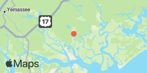
Location & Map
Latitude
32° 36' 6" N (32.6017)
Longitude
80° 32' 30" W (-80.5417)
State
County
Nearest ZIP
29446
Nearby
Tides
2.4 mi
Fields Point, Combahee River
2.9 mi
Bowles Island, New Chehaw River, Combahee River
3.3 mi
Bluff Islands, Ashepoo River
3.6 mi
Brickyard Ferry, swing bridge, Ashepoo River
4.6 mi
Airy Hall Plantation, Ashepoo River
4.9 mi
Hutchinson Island, Ashepoo River
5.5 mi
Summerhouse Point, Bull River, Coosaw River
5.7 mi
Musselboro Island, Mosquito Creek, Ashepoo River
5.9 mi
White House Woods, Mosquito Creek, Ashepoo River, St. Helena Sound
7.5 mi
Ashepoo-Coosaw Cutoff, ICWW, Ashepoo River
7.6 mi
Briars Creek ent., Wimbee Creek, Bull River, Coosaw River
7.7 mi
Fenwick Island, South Edisto River
8.9 mi
Sams Point, Lucy Point Creek, Coosaw River
8.9 mi
Pine Landing, South Edisto River
8.9 mi
U.S. 17 Bridge, Combahee River
9.1 mi
Willtown Bluff, Edisto River, South Edisto River
9.4 mi
Whale Branch entrance, Coosaw River
9.5 mi
Dawho River, South Edisto River
9.5 mi
Hope Creek, Edisto River, South Edisto River
9.6 mi
Seabrook, Ashepoo River
9.8 mi
Ashepoo, Ashepoo River
9.9 mi
Penny Creek, south of, Edisto River, South Edisto River
10.7 mi
Edding Point, Edding Creek, Morgan River
10.8 mi
Air Station Beaufort, McCalleys Creek
11.1 mi
Village Creek Entrance, Morgan River
11.1 mi
Lucy Point Creek entrance, Morgan River
11.2 mi
Otter Island, St. Helena Sound
11.2 mi
Jenkins Creek, 1 mi. above entrance, Morgan River
11.2 mi
Brickyard Point, Brickyard Creek, Coosaw River
11.5 mi
Windsor Plantation, Russel Creek, North Edisto River
11.8 mi
Jacksonboro Camp, South Edisto River
11.8 mi
Cuckolds Creek, Combahee River
11.9 mi
Dawho Bridge, Dawho River, North Edisto River
12.0 mi
Lobeco, Whale Branch, Coosaw River
Currents
3.8 mi
Combahee River, S. of Fields Point
4.0 mi
Williman Creek
5.2 mi
Combahee River entrance
6.5 mi
Ashepoo Coosaw Cutoff, ICW marker 181
6.7 mi
Ashepoo Coosaw Cutoff, south end
6.8 mi
Morgan Island, North end, Coosaw River
7.1 mi
Jehossee Island, S tip, South Edisto River
7.4 mi
Ashepoo Coosaw Cutoff, ICW marker 169
7.9 mi
Hutchinson Island, N. of, Ashepoo River
8.1 mi
Sams Point, Northeast of, Coosaw River
8.6 mi
Smuggedy Swamp, South Edisto River
8.8 mi
Fenwick Island Cut, South Edisto River
8.8 mi
Morgan Island, NE of, Coosaw River
8.9 mi
Parrot Creek, Coosaw Island
9.1 mi
Sampson Island, NE end, South Edisto Riv.
9.1 mi
Sampson Island, S end, South Edisto Riv.
10.1 mi
Ashepoo River, off Jefford Creek
10.2 mi
Whale Branch River
10.7 mi
Coosaw Island, South of, Morgan River
12.0 mi
Whooping Island, Dawho River
12.1 mi
Pelican Bank, St. Helena Sound
12.4 mi
Pine Island, South Edisto River
Note: Tide predictions are an estimate and NOT FOR NAVIGATION.
We also offer free widgets if you want to add tide or solunar tables to your own site.