Hashamomuck Beach Tides & Fishing Times
Tides
Hashamomuck Beach tide chart key:
The tide chart above shows the times and heights of high tide and low tide for Hashamomuck Beach, as well as solunar period times (represented by fish icons). The red line highlights the current time and estimated height.| Day | Tide | Time | Height |
|---|---|---|---|
| 11 Mon | ▼ Low | 0.07 ft | |
| 12 Tue | ▲ High | 4.89 ft | |
| 12 Tue | ▼ Low | -0.1 ft | |
| 12 Tue | ▲ High | 5 ft | |
| 12 Tue | ▼ Low | 0.05 ft | |
| 13 Wed | ▲ High | 4.78 ft |
Tuesday, August 12, 2025 7:59 AM: The tide is currently rising at Hashamomuck Beach with a current estimated height of -0.1 ft. The last tide was Low at 7:50 AM and the next tide is a High of 5 ft at 2:14 PM. The tidal range today is approximately 5.1 ft with a minimum tide of -0.1 ft and maximum tide of 5 ft.
Next 7 Days
▲ Blue = High Tide
▼ Red = Low Tide
| Day | 1st Tide | 2nd Tide | 3rd Tide | 4th Tide | ☀ Sun |
Major Solunars
|
Minor Solunars
|
|
|---|---|---|---|---|---|---|---|---|
| 12 Tue |
|
▲ 4.89 ft |
▼ -0.1 ft |
▲ 5 ft |
▼ 0.05 ft |
▲ 5:57 AM ▼ 7:52 PM |
3:17 AM → 5:17 AM 3:34 PM → 5:34 PM |
9:33 AM → 10:33 AM 9:35 PM → 10:35 PM |
| 13 Wed |
|
▲ 4.78 ft |
▼ -0.03 ft |
▲ 5.06 ft |
▼ 0.09 ft |
▲ 5:58 AM ▼ 7:51 PM |
4:04 AM → 6:04 AM 4:22 PM → 6:22 PM |
10:46 AM → 11:46 AM 9:59 PM → 10:59 PM |
| 14 Thu |
|
▲ 4.61 ft |
▼ 0.1 ft |
▲ 5.06 ft |
▼ 0.17 ft |
▲ 5:59 AM ▼ 7:49 PM |
4:54 AM → 6:54 AM 5:13 PM → 7:13 PM |
12:01 PM → 1:01 PM 10:26 PM → 11:26 PM |
| 15 Fri |
|
▲ 4.41 ft |
▼ 0.27 ft |
▲ 4.98 ft |
▼ 0.28 ft |
▲ 6:00 AM ▼ 7:48 PM |
5:46 AM → 7:46 AM 6:08 PM → 8:08 PM |
1:17 PM → 2:17 PM 10:59 PM → 11:59 PM |
| 16 Sat |
|
▲ 4.21 ft |
▼ 0.45 ft |
▲ 4.86 ft |
▲ 6:01 AM ▼ 7:46 PM |
6:42 AM → 8:42 AM 7:07 PM → 9:07 PM |
2:34 PM → 3:34 PM 11:40 PM → 12:40 AM |
|
| 17 Sun |
|
▼ 0.37 ft |
▲ 4.06 ft |
▼ 0.58 ft |
▲ 4.75 ft |
▲ 6:02 AM ▼ 7:45 PM |
7:41 AM → 9:41 AM 8:09 PM → 10:09 PM |
3:47 PM → 4:47 PM |
| 18 Mon |
|
▼ 0.41 ft |
▲ 4.02 ft |
▼ 0.63 ft |
▲ 4.71 ft |
▲ 6:03 AM ▼ 7:43 PM |
8:43 AM → 10:43 AM 9:13 PM → 11:13 PM |
12:32 AM → 1:32 AM 4:53 PM → 5:53 PM |
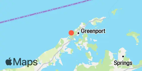
Location & Map
Latitude
41° 5' 42" N (41.095)
Longitude
72° 23' 54" W (-72.3983)
State
County
Nearest ZIP
11944
Nearby
Tides
2.0 mi
Greenport, Shelter Island Sound
2.5 mi
Southold, Shelter Island Sound
5.6 mi
Orient Harbor, Orient, Shelter Island Sound
7.7 mi
Noyack Bay, Shelter Island Sound
8.1 mi
New Suffolk, Peconic Bays
8.3 mi
Sag Harbor, Shelter Island Sound
10.2 mi
Mattituck Inlet, Long Island Sound
11.4 mi
Plum Gut Harbor, Plum Island, Long Island
11.6 mi
Threemile Harbor entrance, Gardiners Bay, Long Island
12.0 mi
Saybrook Jetty, Connecticut River
Currents
1.6 mi
Jennings Point, 0.2 mile NNW of
3.1 mi
Horton Point, 1.4 miles NNW of
3.4 mi
Paradise Point, 0.4 mile east of
4.0 mi
Rocky Point, 0.3 mile north of
4.8 mi
Little Peconic Bay entrance
4.8 mi
Long Beach Pt., 0.7 mile southwest of
5.5 mi
Six Mile Reef, 2 miles south of, Buoy TE
5.5 mi
North Haven Peninsula, north of
6.5 mi
Six Mile Reef, 2 miles east of
6.7 mi
Cornfield Point, 4 miles south of, Buoy CF
7.0 mi
Ram Island, 1.4 miles NNE of
7.3 mi
Six mile Reef, 1 mile south of
7.8 mi
Cedar Point, 0.2 mile west of
8.4 mi
Mulford Point, 3.1 miles northwest of
8.8 mi
Duck Pond Point, 3.2 n.mi. NW of
8.8 mi
Ram Island, 2.2 miles east of
9.1 mi
Orient Point, 1 mile WNW of
9.1 mi
Six Mile Reef, 1.5 miles north of
9.9 mi
Six Mile Reef, 1 mile west of
10.0 mi
Cornfield Point, 2.8 n.mi. SE of
10.1 mi
Hammonasset Point, 5 miles south of
10.1 mi
Mattituck Inlet, 1 mile northwest of
10.2 mi
Cornfield Point, 1.9 n.mi. SW of
10.3 mi
Orient Point, 2.4 miles SSE of
10.3 mi
Kelsey Point, 2.1 miles southeast of
10.3 mi
Cornfield Point, 1.1 miles south of
10.4 mi
Robins Island, 0.5 mile south of
10.9 mi
Plum Gut
10.9 mi
Kelsey Point, 1 mile south of
11.3 mi
Saybrook Breakwater, 1.5 miles SE of
11.7 mi
Saybrook Breakwater Light
Note: Tide predictions are an estimate and NOT FOR NAVIGATION.
We also offer free widgets if you want to add tide or solunar tables to your own site.