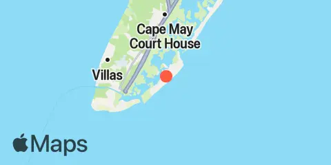
Latitude
38° 58' 30" N (38.975)
Longitude
74° 49' 24" W (-74.8233)
State
County
Nearest ZIP
08260
Nearby
Tides
0.8 mi
Wildwood Crest, Sunset Lake, Cape May Inlet
2.1 mi
West Wildwood, Grassy Sound, Hereford Inlet
2.2 mi
Swain Channel, Taylor Sound, Cape May Inlet
3.2 mi
Old Turtle Thorofare, RR. bridge, Hereford Inlet
3.9 mi
Nummy Island, Grassy Sound Channel, Hereford Inlet
4.1 mi
Cape May Harbor, Cape May Inlet
5.2 mi
Cape Island Creek, Cape May
6.5 mi
Stone Harbor, Great Channel, Hereford Inlet
6.8 mi
Cape May (Ocean)
7.4 mi
Cape May Canal, Cape May, Delaware Bay
7.6 mi
North Highlands Beach, Delaware Bay
8.2 mi
Cape May Point, Sunset Beach, Delaware Bay
8.2 mi
Dias Creek, Route 47 bridge, Delaware Bay
9.5 mi
Long Reach, Ingram Thorofare, Townsends Inlet
10.2 mi
Bidwell Creek, Route 47 bridge, Delaware Bay
10.4 mi
Ingram Thorofare, Townsends Inlet
10.7 mi
Stites Sound, Townsends Inlet
11.2 mi
Bidwell Creek entrance, Delaware Bay
11.6 mi
Ocean Drive bridge, Townsends Inlet
Currents
3.3 mi
Cape May Harbor entrance
4.5 mi
Cape May Canal, east end
8.0 mi
Cape May Canal, West End
8.8 mi
McCrie Shoal
9.3 mi
Cape May Channel
9.6 mi
Cape May Point, 1.4 n.mi. SSW of
10.5 mi
Cape May Point, 2.7 n.mi. SSW of
11.1 mi
Bay Shore Channel (north)
