New Millford Weekly Tide Tables and Charts
Tide Chart for Next 7 Days
New Millford weekly tide chart key:
The tide chart above shows the times and heights of high tide and low tide for New Millford, for the next seven days. The red line highlights the current time and estimated height.The tidal range at New Millford for the next seven days is approximately 6.17 ft with a minimum tide of -0.52 ft and maximum tide of 5.65 ft. You can also check out all the daily details on tides & fishing times on the Day tab for New Millford.
Tide Table for Next 7 Days
▲ Blue = High Tide
▼ Red = Low Tide
| Day | 1st Tide | 2nd Tide | 3rd Tide | 4th Tide | ☀ Sun |
Major Solunars
|
Minor Solunars
|
|
|---|---|---|---|---|---|---|---|---|
| 2 Wed |
|
12:53 AM ▲ 5.65 ft |
9:06 AM ▼ -0.43 ft |
1:36 PM ▲ 4.63 ft |
9:06 PM ▼ -0.1 ft |
▲ 6:37 AM ▼ 7:22 PM |
4:27 AM → 6:27 AM 5:00 PM → 7:00 PM |
8:58 AM → 9:58 AM |
| 3 Thu |
|
1:54 AM ▲ 5.33 ft |
10:05 AM ▼ -0.04 ft |
2:39 PM ▲ 4.38 ft |
10:06 PM ▼ 0.35 ft |
▲ 6:36 AM ▼ 7:23 PM |
5:32 AM → 7:32 AM 6:02 PM → 8:02 PM |
1:12 AM → 2:12 AM 9:52 AM → 10:52 AM |
| 4 Fri |
|
2:57 AM ▲ 4.99 ft |
11:13 AM ▼ 0.27 ft |
3:42 PM ▲ 4.2 ft |
11:18 PM ▼ 0.7 ft |
▲ 6:34 AM ▼ 7:25 PM |
6:35 AM → 8:35 AM 7:02 PM → 9:02 PM |
2:15 AM → 3:15 AM 10:55 AM → 11:55 AM |
| 5 Sat |
|
3:59 AM ▲ 4.71 ft |
12:23 PM ▼ 0.41 ft |
4:44 PM ▲ 4.11 ft |
▲ 6:32 AM ▼ 7:26 PM |
7:35 AM → 9:35 AM 7:58 PM → 9:58 PM |
3:07 AM → 4:07 AM 12:04 PM → 1:04 PM |
|
| 6 Sun |
|
12:31 AM ▼ 0.84 ft |
5:03 AM ▲ 4.5 ft |
1:26 PM ▼ 0.41 ft |
5:48 PM ▲ 4.12 ft |
▲ 6:31 AM ▼ 7:27 PM |
8:30 AM → 10:30 AM 8:52 PM → 10:52 PM |
3:47 AM → 4:47 AM 1:13 PM → 2:13 PM |
| 7 Mon |
|
1:37 AM ▼ 0.8 ft |
6:10 AM ▲ 4.41 ft |
2:22 PM ▼ 0.32 ft |
6:51 PM ▲ 4.28 ft |
▲ 6:29 AM ▼ 7:28 PM |
9:19 AM → 11:19 AM 9:38 PM → 11:38 PM |
4:18 AM → 5:18 AM 2:21 PM → 3:21 PM |
| 8 Tue |
|
2:34 AM ▼ 0.65 ft |
7:13 AM ▲ 4.46 ft |
3:10 PM ▼ 0.21 ft |
7:45 PM ▲ 4.53 ft |
▲ 6:28 AM ▼ 7:29 PM |
10:04 AM → 12:04 PM 10:21 PM → 12:21 AM |
4:43 AM → 5:43 AM 3:26 PM → 4:26 PM |
Current Weather
Air Temperature
38.5° F
Water Temperature
45.3° F
Atmospheric Pressure
30.39 in
Note: Observations are from a weather buoy 16.2 miles from the prediction site. Observations are not available at all prediction sites, and the number/type of observations varies between sites.
More details: Station batn6 Buoy Weather
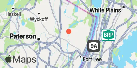
Location & Map
Latitude
40° 56' 6" N (40.935)
Longitude
74° 1' 48" W (-74.03)
State
County
Nearest ZIP
07661
Nearby
Tides
3.8 mi
Hackensack, Hackensack River
5.9 mi
Alpine, Hudson River
5.9 mi
Ridgefield Park, Hackensack River
6.3 mi
Riverdale, Hudson River
6.7 mi
Spuyten Duyvil Creek Entrance, Hudson River
6.8 mi
Ferry Slip, Dyckman Street, Hudson River
7.7 mi
East Rutherford, Passaic River
8.8 mi
Edgewater, Hudson River
9.0 mi
Carlstadt, Garretts Reach, Hackensack River
9.1 mi
North Secaucus, Garretts Reach, Hackensack River
10.3 mi
Fish Creek, Berrys Creek, Hackensack River
10.7 mi
Harlem River, Randalls Island, East River
11.2 mi
Port Morris (Stony Point), East River
11.7 mi
North Brother Island, East River
11.7 mi
Hell Gate, Wards Island, East River
11.8 mi
Weehawken, Union City, Hudson River
11.9 mi
Horns Hook, East 90th Street, East River, New York
11.9 mi
Belleville, Passaic River
12.4 mi
Hunts Point, East River
Currents
6.4 mi
Riverdale
6.6 mi
Spuyten Duyvil
6.7 mi
Mount St. Vincent College, SW of
6.9 mi
Henry Hudson Bridge, 0.7 nmi. SE of
7.2 mi
George Washington Bridge
7.5 mi
Broadway Bridge
7.8 mi
West 207th Street Bridge
8.2 mi
High Bridge
8.9 mi
Macombs Dam Bridge
9.4 mi
Grants Tomb
9.5 mi
Dobbs Ferry
9.8 mi
Madison Ave. Bridge
10.4 mi
Willis Ave. Bridge, 0.1 mile NW of
11.4 mi
Harlem River, south end
11.5 mi
Hudson River, Pier 92
11.7 mi
South Brother Island, NW of
11.8 mi
Off Winthrop Ave., Astoria
11.9 mi
Hell Gate
12.0 mi
Tappan Zee Bridge
12.1 mi
Hunts Point, southwest of
12.2 mi
Hutchinson R., Pelham Highway Bridge
12.4 mi
Roosevelt Is., west of, off 75th Street
Note: Tide predictions are an estimate and NOT FOR NAVIGATION.
We also offer free widgets if you want to add tide or solunar tables to your own site.