TidesPro
  • Recents
    • Dinner Point Creek, upper end, Little Egg Harbor
  • Tides
    United States
    Alabama Alaska California Connecticut Delaware District of Columbia Florida Georgia Hawaii
    Louisiana Maine Maryland Massachusetts Mississippi New Hampshire New Jersey New York North Carolina
    Oregon Pennsylvania Rhode Island South Carolina Texas US Outlying Islands Virginia Washington Puerto Rico
    Caribbean
    The Bahamas Cayman Islands Cuba Dominican Republic Haiti Jamaica Virgin Islands (US)
  • Fishing  Coordinates
    Alabama - Alabama Inshore Public Reefs Alabama - Alabama Nearshore Public Reefs Alabama - Alabama Offshore Public Reefs California - California Artificial Reefs Delaware - Delaware Artificial Reefs Florida - Bay County Florida - Brevard County Florida - Broward County Florida - Charlote and Lee Counties Florida - Citrus County Florida - Collier County Florida - Dixie County Florida - Duval County Florida - Escambia County Florida - Flagler County Florida - Florida Keys Florida - Franklin County Florida - Gulf County Florida - Hernando County
    Florida - Indian River County Florida - Levy County Florida - Manatee County Florida - Martin County Florida - Miami-Dade County Florida - Monroe County Florida - Nassau County Florida - Okaloosa County Florida - Palm Beach County Florida - Pasco County Florida - Santa Rosa County Florida - Sarasota County Florida - St. Johns County Florida - St. Lucie County Florida - Tampa Bay Florida - Taylor County Florida - Volusia County Florida - Wakulla County Florida - Walton County
    Georgia - Georgia Reefs Hawaii - Hawaii Artificial Reefs Louisiana - Louisiana Artificial Reefs Maryland - Maryland Artificial Reefs Massachusetts - Massachusetts Artificial Reefs Mississippi - Mississippi Inshore Artificial Reefs Mississippi - Mississippi Offshore Artificial Reefs New Jersey - New Jersey Artificial Reefs New York - New York Artificial Reefs North Carolina - Estuarine North Carolina - Long Bay North Carolina - Onslow Bay North Carolina - Outer Banks North Carolina - Raleigh Bay Puerto Rico - Puerto Rico Artificial Reefs Rhode Island - Rhode Island Artificial Reefs South Carolina - South Carolina Reefs Texas - Texas Artificial Reefs Virginia - Virginia Artificial Reefs
  • Solunar Tables
Dinner Point Creek Location
  1. United States
  2. New Jersey
  3. Dinner Point Creek, upper end, Little Egg Harbor

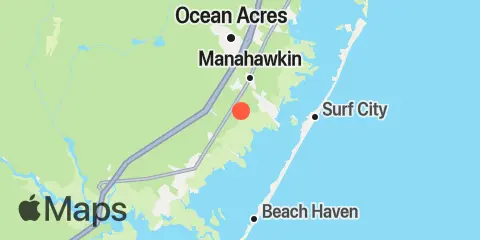
Dinner Point Creek Map

Day Week Month Table Month Chart Map
Latitude
39° 39' 24" N (39.6567)
Longitude
74° 16' 12" W (-74.27)
State
New Jersey
County
Ocean County
Nearest ZIP
08092
Nearby
Tides 0.7 mi Cedar Run, Little Egg Harbor 2.1 mi Mill Creek, 1 n.mi. above entrance, Little Egg Harbor 2.2 mi West Creek, Westecunk Creek, Little Egg Harbor 3.0 mi Manahawkin Creek, Manahawkin Bay 3.0 mi Westecunk Creek entrance, Little Egg Harbor 3.5 mi Parker Run, upper end, Little Egg Harbor 4.4 mi Beach Haven Crest, Little Egg Harbor 4.5 mi Manahawkin Drawbridge, Manahawkin Bay 5.4 mi Tuckerton, Tuckerton Creek, Little Egg Harbor 5.4 mi Flat Creek, Manahawkin Bay 6.0 mi North Beach, Manahawkin Bay 6.4 mi Tuckerton Creek entrance, Little Egg Harbor 7.1 mi Double Creek, Barnegat Bay 7.5 mi Beach Haven Coast Guard Station, Little Egg Harbor 8.5 mi Loveladies Harbor, Barnegat Bay 9.7 mi Little Sheepshead Creek, Great Bay 10.2 mi Graveling Point, Great Bay 10.2 mi New Gretna, Bass River, Mullica River 10.2 mi High Bar, Barnegat Bay 10.3 mi Seven Island, Newmans Thorofare, Great Bay 10.5 mi Waretown, Barnegat Bay 10.7 mi Shooting Thorofare, Little Egg Inlet, Great Bay 11.1 mi Barnegat Inlet, USCG Station, Barnegat Bay 11.3 mi Oyster Creek, Barnegat Bay 12.4 mi Wading River (town), Wading River, Mullica River Currents 4.6 mi Manahawkin Drawbridge 11.2 mi Barnegat Inlet

About

TidesPro was created as an easy-to-use tides and solunar site. It provides tide predictions and marine weather for many types of people, whether you’re fishing, going to the beach, boating, kayaking, surfing, or planning a trip. With anglers in mind, it also provides an accessible way to find fishing spots and the best times to fish in those locations.

More About TidesPro

App

Apple App Store
[More Info]
Quick Links
  • When to Fish
  • Solunar Theory
  • Tide & Solunar Widgets for Your Site
  • Tide & Solunar Predictions in Google Earth
  • Things to Do
  • About

© Copyright 2017 - 2025 ASR Concepts LLC. All rights reserved.

  • Privacy Policy
  • •
  • Terms of Use
  • •
  • Contact
  • •
  • Bluesky
  • •
  • Mastodon
  • •
  • Instagram