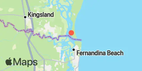
Latitude
30° 43' 36" N (30.7267)
Longitude
81° 28' 36" W (-81.4767)
State
County
Nearest ZIP
31558
Nearby
Tides
1.5 mi
Cut 1N front range, St. Marys River
1.9 mi
St. Marys Entrance, North Jetty
2.5 mi
Dungeness, Seacamp Dock
3.7 mi
Kings Bay, MSF Pier, Cumberland Sound
3.9 mi
Fernandina Beach, Amelia River
4.3 mi
St. Marys, St. Marys River
4.5 mi
Chester, Bells River
5.3 mi
Kings Bay, Navy Base
6.2 mi
Roses Bluff, Bells River
6.4 mi
Lofton, Lanceford Creek
6.6 mi
Kingsley Creek, RR. bridge
8.1 mi
Crooked River, Cumberland Dividings
8.6 mi
Crandall, St. Marys River
8.9 mi
Vaughns Landing
9.7 mi
Amelia City, South Amelia River
11.2 mi
Nassauville, Nassau River East
11.8 mi
Cuno, Lofton Creek, Nassau River
11.8 mi
Harrietts Bluff, Crooked River
Currents
0.5 mi
Range A2, LB 29, Cumberland Sound
1.2 mi
Fort Clinch, 1.1 n.mi. NW of
1.5 mi
Range A, LB 23, St Marys River
1.8 mi
Quarantine Reach, 0.4nm W of Fort Clinch
2.3 mi
Drum Point Island, Range D Channel
2.3 mi
St. Mary's River Entrance
3.0 mi
Old Fernandina, Amelia River, Old Town Reach
3.4 mi
Range E, LB 43, Cumberland Sound
3.9 mi
St Marys Entrance, LB 19
3.9 mi
Fernandina Beach, City Front Reach, Amelia River
4.4 mi
Kings Bay, Site VI
4.8 mi
south jetty
5.8 mi
Stafford Island, west of
6.3 mi
St Marys Entrance, LB 13
6.3 mi
Kings Bay, North Turning Basin
6.8 mi
Kingsley Creek, highway bridge
10.9 mi
Cabin Bluff, Cumberland River
