Point Ybel Tides & Fishing Times
Tides
Point Ybel tide chart key:
The tide chart above shows the times and heights of high tide and low tide for Point Ybel, as well as solunar period times (represented by fish icons). The red line highlights the current time and estimated height.| Day | Tide | Time | Height |
|---|---|---|---|
| 30 Fri | ▼ Low | -0.38 ft | |
| 31 Sat | ▲ High | 2.97 ft | |
| 1 Sun | ▼ Low | -0.16 ft |
Saturday, May 31, 2025 5:47 AM: The tide is currently rising at Point Ybel with a current estimated height of 0.8 ft. The last tide was Low at 11:27 PM and the next tide is a High of 2.97 ft at 3:14 PM.
Solunars & Sun/Moon Times
Waxing Crescent
 20%
20%
Moonset
12:11 AM
Moonrise
11:03 AM
Sunrise
6:35 AM
Sunset
8:17 PM
Buoy Weather
Air Temperature
82.6° F
Water Temperature
87.3° F
Wind
2.9 knots SW (230°)
Wind Gust
8 knots
Atmospheric Pressure
29.91 in
Note: Observations are from a weather buoy 16.33 miles from the prediction site. Observations are not available at all prediction sites, and observation types vary between sites.
More details: Station fmrf1 Buoy Weather
Next 7 Days
▲ Blue = High Tide
▼ Red = Low Tide
| Day | 1st Tide | 2nd Tide | 3rd Tide | 4th Tide | ☀ Sun |
Major Solunars
|
Minor Solunars
|
|
|---|---|---|---|---|---|---|---|---|
| 31 Sat |
|
▲ 2.97 ft |
▲ 6:35 AM ▼ 8:17 PM |
5:37 AM → 7:37 AM 5:59 PM → 7:59 PM |
12:11 AM → 1:11 AM 11:03 AM → 12:03 PM |
|||
| 1 Sun |
|
▼ -0.16 ft |
▲ 2.64 ft |
▲ 6:35 AM ▼ 8:17 PM |
6:27 AM → 8:27 AM 6:47 PM → 8:47 PM |
12:51 AM → 1:51 AM 12:04 PM → 1:04 PM |
||
| 2 Mon |
|
▼ 0.08 ft |
▲ 1.84 ft |
▼ 1.62 ft |
▲ 2.3 ft |
▲ 6:35 AM ▼ 8:17 PM |
7:13 AM → 9:13 AM 7:31 PM → 9:31 PM |
1:26 AM → 2:26 AM 1:00 PM → 2:00 PM |
| 3 Tue |
|
▼ 0.35 ft |
▲ 1.98 ft |
▼ 1.35 ft |
▲ 2 ft |
▲ 6:35 AM ▼ 8:18 PM |
7:55 AM → 9:55 AM 8:12 PM → 10:12 PM |
1:56 AM → 2:56 AM 1:54 PM → 2:54 PM |
| 4 Wed |
|
▼ 0.63 ft |
▲ 2.16 ft |
▼ 1.01 ft |
▲ 1.81 ft |
▲ 6:35 AM ▼ 8:18 PM |
8:35 AM → 10:35 AM 8:52 PM → 10:52 PM |
2:24 AM → 3:24 AM 2:46 PM → 3:46 PM |
| 5 Thu |
|
▼ 0.91 ft |
▲ 2.36 ft |
▼ 0.66 ft |
▲ 1.74 ft |
▲ 6:35 AM ▼ 8:19 PM |
9:14 AM → 11:14 AM 9:32 PM → 11:32 PM |
2:52 AM → 3:52 AM 3:37 PM → 4:37 PM |
| 6 Fri |
|
▼ 1.18 ft |
▲ 2.56 ft |
▼ 0.36 ft |
▲ 1.74 ft |
▲ 6:35 AM ▼ 8:19 PM |
9:54 AM → 11:54 AM 10:12 PM → 12:12 AM |
3:20 AM → 4:20 AM 4:28 PM → 5:28 PM |
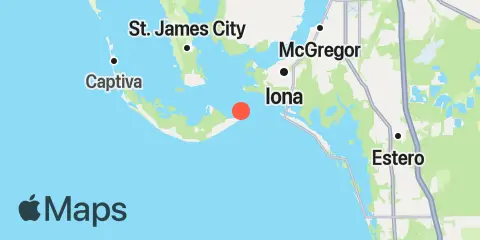
Location & Map
Latitude
26° 27' 0" N (26.45)
Longitude
82° 1' 0" W (-82.01667)
State
County
Nearest ZIP
33957
Nearby
Tides
2.7 mi
Punta Rassa, San Carlos Bay
4.0 mi
Matanzas Pass (fixed bridge) Estero Island
4.1 mi
Tarpon Bay, Sanibel Island
5.0 mi
St. James City, Pine Island
5.9 mi
Iona Shores, Caloosahatchee River
6.1 mi
Estero Island, Estero Bay
7.1 mi
Galt Island, Pine Island Sound
7.8 mi
Tropical Homesites Landing, Pine Island
8.7 mi
Carlos Point, Estero Bay
8.8 mi
Hendry Creek, Estero Bay
9.4 mi
Cape Coral Bridge, Caloosahatchee River
10.0 mi
Estero River, Estero Bay
10.5 mi
Captiva Island (Outside)
11.3 mi
Coconut Point, Estero Bay
11.7 mi
Captiva Island, Pine Island Sound
12.0 mi
Little Hickory Island, Estero Bay
Currents
0.5 mi
Point Ybel, 0.4 mile northwest of
Note: Tide predictions are an estimate and NOT FOR NAVIGATION.
We also offer free widgets if you want to add tide or solunar tables to your own site.