Unfortunately, this tide station is no longer active, and predictions are no longer accurate.
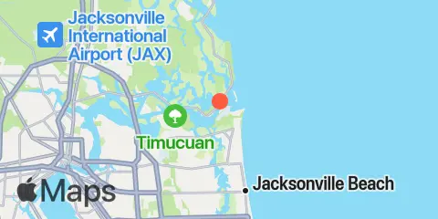
You can check out the map below -- any nearby locations will be displayed on the map and list below. Alternatively, you can browse the site for other active locations.
Location & Map
Latitude
30° 23' 42" N (30.395)
Longitude
81° 25' 54" W (-81.4317)
State
County
Nearest ZIP
32233
Nearby
Tides
0.1 mi
Mayport (Ferry Depot)
0.3 mi
Bar Pilot Dock, St. Johns River
1.2 mi
Water Treatment Dock, Mayport Naval Station, St Johns River
1.6 mi
Pablo Creek entrance
2.0 mi
Sisters Creek
2.2 mi
Degaussing structure, Mayport Naval Station
2.9 mi
Little Talbot Island, Ocean
3.1 mi
Fort George Island, Fort George River
4.5 mi
Fulton
4.7 mi
Atlantic Beach
4.7 mi
Clapboard Creek, Pelotes Island
4.8 mi
Simpson Creek, A1A highway bridge
5.0 mi
Pablo Creek, ICWW bridge
6.9 mi
Blount Island Bridge
7.6 mi
Dame Point, St. Johns River
7.9 mi
Sawpit Creek, 1 mi. above entrance
8.2 mi
Jacksonville Beach
8.3 mi
Tiger Point, Pumpkin Hill Creek, Nassau River
8.3 mi
Sawpit Creek entrance, bridge
8.6 mi
Nassau River entrance
9.8 mi
Oak Landing, ICWW
9.9 mi
Edwards Creek, Nassau River
11.5 mi
Jacksonville, Long Branch
11.6 mi
Jacksonville, Navy Fuel Depot
12.2 mi
Little Pottsburg Creek
12.3 mi
Phoenix Park
Currents
0.2 mi
Mayport
1.0 mi
Mile Point LB 20
1.7 mi
ICW Intersection
1.8 mi
Sisters Creek entrance (bridge)
2.1 mi
St. Johns Bar Cut, 0.7 n.mi. east of jetties
2.2 mi
Mayport Basin Entrance
2.8 mi
St. Johns River Ent. (between jetties)
3.5 mi
Bar Cut, 0.6 n.mi. ENE of St. John's Point
3.9 mi
St. Johns Bluff
4.4 mi
Ft. George River
4.6 mi
Blount Island, East of
5.0 mi
Pablo Creek bascule bridge
7.3 mi
Dames Point, 0.23 n.mi. ESE of
7.6 mi
Dames Point Bridge
9.0 mi
Midsound, 1 mi. N of Sawpit Creek entrance
10.0 mi
Nassau River, SW of Mesa Marsh
10.0 mi
South Amelia River, off Walker Creek
10.3 mi
Drummond Point, channel south of
11.4 mi
Terminal Channel (north end)
11.6 mi
Reddie Point
11.7 mi
Trout River Cut
11.8 mi
Chaseville Turn
