Matlacha Pass (Bascule Bridge) Weekly Tide Tables and Charts
Tide Chart for Next 7 Days
Matlacha Pass (Bascule Bridge) weekly tide chart key:
The tide chart above shows the times and heights of high tide and low tide for Matlacha Pass (Bascule Bridge), for the next seven days. The red line highlights the current time and estimated height.The tidal range at Matlacha Pass (Bascule Bridge) for the next seven days is approximately 2.75 ft with a minimum tide of -0.46 ft and maximum tide of 2.29 ft. You can also check out all the daily details on tides & fishing times on the Day tab for Matlacha Pass (Bascule Bridge).
Tide Table for Next 7 Days
▲ Blue = High Tide
▼ Red = Low Tide
| Day | 1st Tide | 2nd Tide | 3rd Tide | 4th Tide | ☀ Sun |
Major Solunars
|
Minor Solunars
|
|
|---|---|---|---|---|---|---|---|---|
| 1 Thu |
|
▼ -0.46 ft |
▲ 2.19 ft |
▲ 6:50 AM ▼ 8:01 PM |
4:53 AM → 6:53 AM 5:23 PM → 7:23 PM |
10:04 AM → 11:04 AM |
||
| 2 Fri |
|
▼ -0.36 ft |
▲ 2.01 ft |
▲ 6:49 AM ▼ 8:01 PM |
5:57 AM → 7:57 AM 6:23 PM → 8:23 PM |
12:44 AM → 1:44 AM 11:10 AM → 12:10 PM |
||
| 3 Sat |
|
▼ -0.24 ft |
▲ 1.07 ft |
▼ 1.02 ft |
▲ 1.77 ft |
▲ 6:49 AM ▼ 8:02 PM |
6:54 AM → 8:54 AM 7:18 PM → 9:18 PM |
1:35 AM → 2:35 AM 12:14 PM → 1:14 PM |
| 4 Sun |
|
▼ -0.12 ft |
▲ 1.13 ft |
▼ 0.95 ft |
▲ 1.52 ft |
▲ 6:48 AM ▼ 8:03 PM |
7:47 AM → 9:47 AM 8:07 PM → 10:07 PM |
2:18 AM → 3:18 AM 1:16 PM → 2:16 PM |
| 5 Mon |
|
▼ 0.02 ft |
▲ 1.23 ft |
▼ 0.8 ft |
▲ 1.37 ft |
▲ 6:47 AM ▼ 8:03 PM |
8:33 AM → 10:33 AM 8:53 PM → 10:53 PM |
2:54 AM → 3:54 AM 2:13 PM → 3:13 PM |
| 6 Tue |
|
▼ 0.17 ft |
▲ 1.37 ft |
▼ 0.59 ft |
▲ 1.29 ft |
▲ 6:46 AM ▼ 8:04 PM |
9:17 AM → 11:17 AM 9:35 PM → 11:35 PM |
3:26 AM → 4:26 AM 3:08 PM → 4:08 PM |
| 7 Wed |
|
▼ 0.33 ft |
▲ 1.52 ft |
▼ 0.36 ft |
▲ 6:46 AM ▼ 8:04 PM |
9:57 AM → 11:57 AM 10:15 PM → 12:15 AM |
3:55 AM → 4:55 AM 4:00 PM → 5:00 PM |
Buoy Weather
Air Temperature
79.5° F
Water Temperature
79.5° F
Wind
4.1 knots E (80°)
Wind Gust
11.1 knots
Atmospheric Pressure
30.12 in
Note: Observations are from a weather buoy 12.24 miles from the prediction site. Observations are not available at all prediction sites, and observation types vary between sites.
More details: Station fmrf1 Buoy Weather
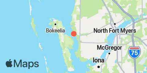
Location & Map
Latitude
26° 37' 54" N (26.6317)
Longitude
82° 4' 6" W (-82.0683)
State
County
Nearest ZIP
33993
Nearby
Tides
5.7 mi
Pineland, Pine Island
5.8 mi
Tropical Homesites Landing, Pine Island
7.8 mi
Bokeelia, Charlotte Harbor
8.5 mi
Galt Island, Pine Island Sound
9.5 mi
North Captiva Island
9.6 mi
Cape Coral Bridge, Caloosahatchee River
9.7 mi
St. James City, Pine Island
9.7 mi
Redfish Pass, Captiva Island (North End)
9.9 mi
Iona Shores, Caloosahatchee River
10.5 mi
Punta Rassa, San Carlos Bay
10.6 mi
Captiva Island, Pine Island Sound
12.2 mi
Fort Myers, Caloosahatchee River
Currents
9.4 mi
Cape Haze, 2.3 mi. S of, Charlotte Hbr
9.6 mi
Captiva Pass
Note: Tide predictions are an estimate and NOT FOR NAVIGATION.
We also offer free widgets if you want to add tide or solunar tables to your own site.