Tides

Port Chicago tide chart key:

The tide chart above shows the times and heights of high tide and low tide for Port Chicago, as well as solunar period times (represented by fish icons). The red line highlights the current time and estimated height.
2 Fish - Minor Solunar = Minor Solunar / Heightened Fish Activity
4 Fish - Major Solunar = Major Solunar / Very Heightened Fish Activity
Day Tide Time Height
20 Fri High 4:45 PM 4.08 ft
21 Sat Low 12:17 AM 0 ft
21 Sat High 7:07 AM 4.03 ft
21 Sat Low 12:46 PM 1.59 ft
21 Sat High 5:53 PM 3.57 ft
22 Sun Low 12:51 AM 0.22 ft

Saturday, December 21, 2024 10:09 PM: The tide is currently falling at Port Chicago with a current estimated height of 1.3 ft. The last tide was High at 5:53 PM and the next tide is a Low of 0.22 ft at 12:51 AM. The tidal range today is approximately 4.03 ft with a minimum tide of 0 ft and maximum tide of 4.03 ft.

Solunars & Sun/Moon Times

Waning Gibbous
Waning Gibbous 68%
Major Solunar
5:13 AM 7:13 AM
5:37 PM 7:37 PM
Minor Solunar
11:41 AM 12:41 PM
11:34 PM 12:34 AM
Moonset
11:41 AM
Moonrise
11:34 PM
Sunrise
7:21 AM
Sunset
4:52 PM

Current Weather

Wind
2.9 knots ESE (120°)
Wind Gust
5.1 knots

Note: Observations are from a weather buoy 4.61 miles from the prediction site. Observations are not available at all prediction sites, and the number/type of observations varies between sites.

More details: Station upbc1 Buoy Weather

Next 7 Days

▲ Blue = High Tide ▼ Red = Low Tide
Day 1st Tide 2nd Tide 3rd Tide 4th Tide Sun Major Solunars Very heightened fish activity Minor Solunars Heightened fish activity
21 Sat Waning Gibbous 68% 12:17 AM
0 ft
7:07 AM
4.03 ft
12:46 PM
1.59 ft
5:53 PM
3.57 ft
7:21 AM 4:52 PM 5:13 AM 7:13 AM
5:37 PM 7:37 PM
11:41 AM 12:41 PM
11:34 PM 12:34 AM
22 Sun Last Quarter 50% 12:51 AM
0.22 ft
7:49 AM
4.06 ft
1:55 PM
1.29 ft
7:13 PM
3.16 ft
7:21 AM 4:53 PM 5:52 AM 7:52 AM
6:17 PM 8:17 PM
12:02 PM 1:02 PM
23 Mon Waning Crescent 49% 1:27 AM
0.5 ft
8:27 AM
4.14 ft
3:04 PM
0.94 ft
8:36 PM
2.94 ft
7:22 AM 4:53 PM 6:31 AM 8:31 AM
6:55 PM 8:55 PM
12:32 AM 1:32 AM
12:22 PM 1:22 PM
24 Tue Waning Crescent 40% 2:05 AM
0.86 ft
9:02 AM
4.29 ft
4:08 PM
0.59 ft
9:52 PM
2.93 ft
7:22 AM 4:54 PM 7:11 AM 9:11 AM
7:36 PM 9:36 PM
1:29 AM 2:29 AM
12:44 PM 1:44 PM
25 Wed Waning Crescent 31% 2:46 AM
1.26 ft
9:33 AM
4.49 ft
5:06 PM
0.28 ft
11:00 PM
3.08 ft
7:23 AM 4:55 PM 7:52 AM 9:52 AM
8:18 PM 10:18 PM
2:28 AM 3:28 AM
1:07 PM 2:07 PM
26 Thu Waning Crescent 23% 3:29 AM
1.68 ft
9:59 AM
4.72 ft
5:58 PM
0.06 ft
7:23 AM 4:55 PM 8:35 AM 10:35 AM
9:03 PM 11:03 PM
3:29 AM 4:29 AM
1:35 PM 2:35 PM
27 Fri Waning Crescent 15% 12:01 AM
3.31 ft
4:15 AM
2.06 ft
10:25 AM
4.96 ft
6:45 PM
-0.09 ft
7:23 AM 4:56 PM 9:23 AM 11:23 AM
9:52 PM 11:52 PM
4:32 AM 5:32 AM
2:09 PM 3:09 PM

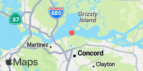
Location & Map

Latitude
38° 3' 22" N (38.056)
Longitude
122° 2' 22" W (-122.0395)
State
Nearest ZIP
94520
Nearby
Tides 3.1 mi Point Buckler, Suisun Bay 4.9 mi Martinez-Amorco Pier 5.0 mi Benicia 5.3 mi Suisun Slough entrance, Suisun Bay 5.9 mi Pierce Harbor, Goodyear Slough, Suisun Bay 6.7 mi Mallard Island Ferry Wharf, Suisun Bay 8.5 mi Montezuma Slough, Suisun Bay 8.6 mi Joice Island, Suisun Slough, Suisun Bay 8.8 mi Pittsburg, New York Slough, Suisun Bay 9.1 mi Meins Landing, Montezuma Slough, Suisun Bay 9.6 mi Montezuma Slough Bridge, Suisun Bay 10.0 mi Crockett, Carquinez Strait 10.5 mi Collinsville, Sacramento River 10.8 mi Nurse Slough, Bradmoor Island, Suisun Bay 11.1 mi Selby 11.5 mi Mare Island Naval Shipyard, Carquinez Strait Currents 0.6 mi Seal Island, south of 0.7 mi Roe Island Channel 1.6 mi Roe Island, Gilbert Pt., 0.15 nmi. NW of 2.5 mi Middle Point Lt., 0.18 nmi. NNW of 2.5 mi Middle Point Lt., 0.18 nmi. NNW of 2.8 mi Avon Pier, 0.15 nmi. north of 2.9 mi Suisun Cutoff 2.9 mi Pt. Edith, 1.7 nmi. NNW of 3.3 mi Grizzly Bay entrance 4.4 mi 0.5 nmi. east of entrance 4.6 mi Stake Point, 0.9 nmi. NNW of 4.8 mi Entrance 4.9 mi Benicia Bridge 5.3 mi Army Pt. Pier Lt. 0.2 nmi. SE of 5.4 mi West entrance 5.9 mi Martinez Marina, 0.61 nmi. NNW of 6.1 mi 1 mile inside entrance 6.2 mi Wilson Point, 1.55 nmi. north of 6.2 mi Martinez Marina, 0.65 nmi. NW of 6.2 mi Martinez Marina, 0.50 nmi. west of 6.4 mi 1 mile inside west entrance 6.4 mi Simmons Point, 0.6nm ESE of 6.4 mi Simmons Pt., Chipps Is., 0.6 nmi. ESE of 7.3 mi Spoonbill Creek, near bridge 8.4 mi Dillon Point 8.6 mi Montezuma Slough, east end, near bridge 9.2 mi Entrance, 0.7nm SW of Chain Island 9.2 mi Entrance, 0.7 mile SW of Chain Island 9.4 mi New York Slough, 0.6miles E of Pt. Emmet 9.4 mi New York Slough, 0.6miles E of Pt. Emmet 9.7 mi Carquinez Strait 10.2 mi Carquinez Bridge, I-80 10.3 mi Pt. San Joaquin, 0.45 nmi. ENE of 10.7 mi New York Slough, Winter Island 11.0 mi Point Beenar, 0.7 nmi. north of 11.1 mi Mare Island Strait (Buoy "4") 11.2 mi Point Sacramento, 0.2nm NE of 11.2 mi Point Beenar, 100 yds., NE of 11.2 mi Point Sacramento, 0.3 mile NE OF 11.3 mi Mare Island Strait, NE of Pier 34 11.9 mi Davis Point, (midchannel) 12.0 mi Antioch Point 12.2 mi Antioch Point, 0.3 mile east of

Note: Tide predictions are an estimate and NOT FOR NAVIGATION.

We also offer free widgets if you want to add tide or solunar tables to your own site.