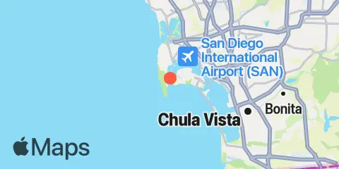
Unfortunately, this tide station is no longer active, and predictions are no longer accurate.
You can check out the map below -- any nearby locations will be displayed on the map and list below. Alternatively, you can browse the site for other active locations.
Location & Map
Latitude
32° 41' 12" N (32.6867)
Longitude
117° 13' 59" W (-117.233)
State
County
Nearest ZIP
92106
Nearby
Tides
1.2 mi
San Diego, Quarantine Station
1.4 mi
Point Loma
3.8 mi
San Diego, San Diego Bay
5.5 mi
Quivira Basin, Mission Bay
6.9 mi
National City, San Diego Bay
7.4 mi
Mission Bay
8.3 mi
South San Diego Bay
9.4 mi
Imperial Beach
Currents
0.2 mi
Ballast Point, south of
0.2 mi
Ballast Point, 100 yards north of
0.4 mi
San Diego Bay Entrance
0.6 mi
Ballast Point, 0.55 nmi. north of
0.9 mi
Quarantine Station, La Playa
1.5 mi
Point Loma Light, 0.8 nmi. east of
2.2 mi
North Island
3.3 mi
Harbor Island (east end), SSW of
3.6 mi
San Diego, 0.5 mile west of
3.6 mi
G St. Pier (San Diego), 0.22 nmi. SW of
4.1 mi
Coronado, off northeast end
4.9 mi
28th St. Pier (San Diego), 0.92 nmi. SW
5.3 mi
28th St. Pier (San Diego), 0.35 nmi. SW
6.5 mi
National City, WSW of Pier 12
7.0 mi
Sweetwater Channel, southwest of
7.2 mi
National City
